The Continental Shelf Programme has software for converting between the various formats referred to below. Most of the conversion software has been developed internally and may lack certain functionality, but can be further developed as new needs arise.
| Data structure and flow |
|
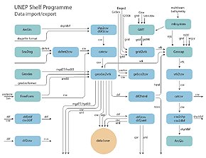
The figure shows the data structure and flow in the One Stop Data Shop. (Click to view high resolution)
|
| Filters |
|
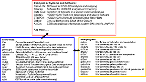
The figure shows how the various filters may be connected to filters and applications. (Click to view high resolution)
|
Data formats
Vector formats:
VTK
The internal vector file format for Geocap (http://www.geocap.no) is 3D Polygonal Data VTK format, see http://www.vtk.org/pdf/file-formats.pdf
Ascii/csv/xy(z)
Text files with data ordered in fixed columns or separated with a delimiter (comma, semicolon, space or tabs). Comma Separated Value (CSV) files can include coordinates (XY) as well as depth/altitude values (Z), and is a very common and useful format for export/import.
Geodas
MGD77/HYD93/ARO88 formats, see http://www.ngdc.noaa.gov/mgg/gdas/hg_mgd2000.Html
DXFMT
SeaDOG fixed column data format, see http://www.noc.soton.ac.uk/CHD/SeaDOG/
Shape/DBF
A popularArcGIS vector format suitable for import/export – see http://downloads.esri.com/support/whitepapers/other_/shapefile.pdf
Dif
Different variations of NASA’s Directory Interchange Format, adapted to the actual vector and metadata files in use, see http://gcmd.gsfc.nasa.gov/User/difguide/difman.html
Xml
Extensible Markup Language, see http://www.w3.org/XML/
Html
HyperText Markup Language, see http://www.w3.org/MarkUp/
SEG-Y
Seismic data formats (http://www.seg.org/publications/tech-stand/seg_y_rev1.doc) accepted by Geocap.
Multibeam bathymetry
Miscellaneous formats for multibeam bathymetry data accepted by the MB-System SW package.
Grid/raster formats:
VTK
The internal grid/raster format for Geocap (http://www.geocap.no) is Structured Points VTK format, see http://www.vtk.org/pdf/file-formats.pdf
Geodas
GRD98, see http://www.ngdc.noaa.gov/mgg/gdas/hg_mgd2000.Html
Others
Raster formats accepted by the GMT SW package, including Etopo2 , NetCDF (http://www.unidata.ucar.edu/software/netcdf/) and others.
Conversion software
Internal filters :
geodas2vtk
Filter to translate Geodas formatted (MGD77, HYD93, ARO88) files into vtk, csv, dif or xml format. Accepts also other xyz csv files for input, as well as dif files conforming to the same format as generated by the filter itself.
vtk2csv
Filter to translate vector VTK files into xyz csv format.
grid2vtk
Filter to make cut-outs of and to translate global grid files into VTK format; operates on Etopo2 (http://www.ngdc.noaa.gov/mgg/fliers/01mgg04.html) and pasted together (via GMT) versions of Gebco (http://www.bodc.ac.uk/projects/international/gebco/), Gina (http://www.gina.alaska.edu/page.xml?group=data&page=griddata),
S2004 (ftp://falcon.grdl.noaa.gov/pub/walter/Gebco_SandS_blend.bi2), Srtm30+ (http://topex.ucsd.edu/WWW_html/srtm30_plus.html), as well as
GRDD98 formatted global grid files
catcsv
Filter to concatenate several csv files into one, to reformat csv files, to manipulate with field contents and names, and to weed xy files
dxfmt2csv/gebco2csv
Filters to convert particular fixed column files (DXFMT, Gebco vector files) into csv xyz format
csv2shp/csv2dbf
Filters to generate shapefiles and dbf-files from csv files; can also convert csv files into ArcGIS Generate format
shp2csv/dbf2csv
Filters based on shapelib (http://shapelib.maptools.org/) to extract shapefile points and data on csv format
dif2csv
Filter to convert dif files into csv files modelling a relational database
csv2dif
Filter to convert a set of csv files modelling a relational database into dif
dif2html/dif2xml
Filter to convert dif files into html or xml files
External filters and software packages:
Geocap
A 2d/3d mapping and modelling program in 3d space, comprising dedicated software solutions for calculating the outer limit of the continental shelf, see http://www.geocap.no
FreeForm
Programs for manipulating a wide variety of data in standard and non-standard formats, see http://www.ngdc.noaa.gov/seg/tools/freeform/
GMT
The Generic Mapping Tools, see http://gmt.soest.hawaii.edu/
MB-System
Software for the Processing and Display of Swath Sonar Data, see http://www.ldeo.columbia.edu/res/pi/MB-System/
ArcGis
Integrated collection of GIS software products from ESRI, see http://www.esri.com/software/arcgis/